|
|
 |
 |
   |
|
|
|
|
|

|
|
Here you can find short reports presenting some of the science behind the cruise. Reports will address topics mentioned in the Scientific Objectives as well as other basic geology topics, and are written for a general audience.
|
|
Science Report 6 - 29 March 2012 - Magnetic Anomaly Mapping and Walvis Ridge
A curious property of the Earth�s magnetic field combined with the behavior of volcanic rocks give Earth scientists a powerful tool for understanding the history of ocean basins. The Earth appears unique among the rocky planets in having a strong magnetic field, apparently the result of vigorous convection of fluid iron in the outer core.
What is more, the geomagnetic field generated in the core looks very much like the field of a bar magnet nearly aligned with...
Read more
|
|
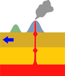
Science Report 5 - 25 March 2012 - Intra-plate Volcanism and Mantle Plumes
Of great interest to geologists is where seamounts occur on the ocean floor. Why does magma break the earth�s crust at these locations and not others? Active plate boundaries, such as mid-ocean ridges (e.g. Iceland) and subduction
zones (e.g. Japan) are clear sources of volcanism, but what processes...
Read more
|
|
Science Report 4 - 16 March 2012 - Seamounts: What are they and how do they form?
Volcanoes are some of the most majestic and well-known expressions of the forces at work in the earth under our feet. Most people have seen photographs of glowing lava flows spilling down the sides of Hawaii�s Kilauea and of explosive eruptions from volcanoes such as Mt. Etna in Italy and Mt. Pinatubo in the Philippines. What many people don�t realize is that the majority of volcanism...Read more
|
|
Science Report 3 - 12 March 2012 - Where can we find Potassium and Argon within Basalt?
(Part 2)
To find the argon we need for age dating rocks, we first need to find potassium. The rocks that we are dredging are volcanic basalts and contain on average 1% potassium by weight...Read more
|
|
Science Report 2 - 9 March 2012 - Pillow Lavas
A distinctive lava flow morphology that has been appearing in our dredges is pillow lava. Pillow lavas form when hot lava flows into water and cools rapidly, creating long tubes and bulbous pillow-shaped mounds of rock. Pillow lavas are found not only...Read more
|
|
Science Report 1 - 7 March 2012 - Determining the Age of a Rock with the K/Ar System (Part 1)
Utilizing the radioactive decay of elements, we can date the rocks that we find on the ocean floor. One of the most common systems that we use is the decay of the Potassium (K) 40 isotope to...Read more
|
|
| Read All Science Reports |
|
|
|
|
|
|
|
|
 |
|
|
|
|
|
|
Here you can find short news updates describing recent events on the cruise and longer blog posts describing aspects of life onboard the R/V Melville.
|
|
Last Update - 29 March 2012 - The Final Report
After 49 days and nights at sea it is time to tally our successes. Almost two months ago we sailed away from Cape Town with a number of exciting science questions in hand and a science crew of 16 to figure them out. Our plan: tackle an area...Read more
|
|
Blog 7 - 28 March 2012 - How to feed 39 People for 7 Weeks
The cruise is nearly over and we are just days from port. I would like to take this opportunity to tell the story of two of the unsung heroes of this trip: the cooks. There are two cooks...Read more
|
|
Blog 6 - 24 March 2012 - Exploring the hidden world of seamounts
In today�s world it is difficult to find a patch of land that has not been explored, named, measured and visited by many already and even the most extreme environments seem to have...Read more
|
|
Days 35-41 - 23 March 2012 - The Final Stretch
As we move into the last week of the cruise, we have finally started to count down the days until we see land again. Following our last update we moved steadily eastwards to two large seamounts: Jahont and R.S.A. While in transit we passed...Read more
|
|
Blog 5 - 16 March 2012 - In Pursuit of Sleep
Everyone has particular requirements when it comes to getting a good night�s rest. Some might need complete silence and some like background sounds, like flowing water. I myself have a set of requirements that need to be met before...Read more
|
|
Days 29-34 - 16 March 2012 - Heading South
Since our last update we have traveled a considerable distance. We continued to dredge seamounts through the solar storm event mentioned in the previous post, and uncovered two very interesting ridge features. The first extends out to Omura seamount, at the western end of a linked chain of smaller seamounts. A similar chain of both individual and linked seamounts stretches eastwards from Risso to Spinner. This second ridge is...Read more
|
|
Days 20-27 - 9 March 2012 - Storm Fronts and
new Science Reports
Since dredging and mapping Moby Dick we have been moving quickly through seamounts. In seven days we have mapped eleven seamounts and conducted nine dredges. We are currently dredging Haviside for the second time. The initial dredge at Haviside was a great success and filled all five of our tables with basalt samples. Haviside
is of particular interest because it is the last large seamount... Read more
|
|
Blog 4 - 3 March 2012 - Letter to a Friend
Hope you're doing well man. I miss the heck out of you. It's really kind of strange going so long without seeing you and Chuck. For the last year or so I have seen you two more than anyone else I think. How was your birthday? I sent you a message on FB, I'm not sure if I was able to get it through. I'm having the experience of a lifetime, can't wait to show you the pictures. While I was in South Africa we I got to go to Cape Point and the Cape of Good Hope, it was stunning... Read more
|
|
Days 16-19 - 1 March 2012 - The Curse of Moby-Dick
We have spent the past few days surveying and dredging (or trying to dredge) a very large seamount and several small seamounts surrounding it. The seamount appeared so large... Read more
|
|
Blog 3 - 28 February 2012 - Orion Does a Cartwheel: The Southern Skies
Lets take a step outside� it�s after my shift, so it is 1:30am and it is pitch black out on the deck. After a few minutes of staring into the dark, my eyes adjust and a swath of white specks reveals... Read more
|
|
Days 11-15 - 26 February 2012 - Fracture Zone Fishin'
On Feb. 21 we reached the northern limit of our cruise at the seamount named Peleg after dredging Mystic and Morgan to the south. We then turned to the southwest where we dredged and mapped five more seamounts: Bildad, Narwhal, Bottlenose, Elijah and... Read more
|
|
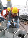
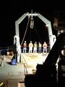
Blog 2 - 25 February 2012 - Dredging for Dummies
Dredging for volcanic rocks on the ocean floor is a crude sampling method of doing Earth science, and success can often arguably be attributed to �pure dumb luck.� However, since each dredge takes hours to complete, and we have so many sites... Read more
|
|
| Read All News Updates | Read All Blog Posts |
|
|
|
|
|
|
|
| |
|
 |
|
|
|
|
|
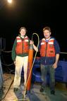
Walvis 2012 Expedition
Browse through a gallery of pictures from the MV1203 cruise, showing life aboard the R/V Melville and the rocks being recovered from the ocean floor.
|

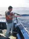
Co-PIs on the Walvis Ridge project: Cornelia Class, Anthony Koppers
(Chief Scientist), William Sager.
|
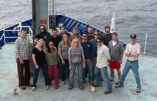
The members of the MV1203 science team.
|
|
| All Participants | View Image Gallery |
|
|
|
|
|
|
|
|
 |
|
|
|
|
|

|
Planned Cruise Path
This map shows the current location of the ship as well as the planned and already traveled ship tracks. The planned route may vary depending on weather and presence of suitable dredge sites at each seamount.
|
|
|
See Larger Version |
|
|
|
|
|
|
|
|
 |
|
|
|
|
|
- Verify the �primary� hotspot model for the young Walvis Ridge and, if possible, derive an improved
absolute plate motion
model for the African Plate.
- Trace the Geochemical Evolution of the Walvis Ridge and genetically link it with the Tristan and Gough subtracks.
- Better understand the role of the Regional Tectonic Setting and the state of lithosphere on the formation of the Tristan and Gough subtracks.
|
|
|
Read More about the Scientific Objectives |
|
|
|
|
|
|
|
|
 |
|
|
|
|
|

180m RESOLUTION
|
Blue Seamount
LAT
40�15.6'S
LON
13�13.8'W
DEPTH 500 m
HEIGHT
3000 m
PREDICTED AGE ~40 Ma
|

2km RESOLUTION
|
|
|
|
See More Maps of Dredge Sites |
|
|
|
|
|
|
|
|
|
|
|
 |
|
|
|
|
|
 Your Editors: Dr. Anthony Koppers, Susan Schnur and Daniel Heaton (Oregon State University)
|
A Dredging We Will Go
A team of 16 students and scientists led by Chief-Scientist Anthony Koppers will be at sea for 7 weeks, conducting magnetic surveys and dredging rocks from over 40 seamounts on the Walvis Ridge. The team consists of 4 undergraduate geology students, 3 recently-graduated geology students, 6 graduate students in geology, geophysics and oceanography, and 3 professors from Oregon State University, Texas A&M University, and Columbia University. Over the next 7 weeks you will have a chance to hear from all of us with different perspectives on the science of the Walvis Ridge and life as part of the science crew on the R/V Melville.
|
|
|
|
|
|
|
|