|
ERESE Master Document Index: |
|
| Teachers Log | Back to index |
| ERESE
Teachers Log |
Clyda
Lutz |
| Lesson
title |
Relationship
of Earthquakes and Volcanic Eruptions to Plate Boundaries |
| Intent
of the lesson |
For
students to understand what phenonema occur to determine whether a
plate boundary is convergent, divergent or transform. |
| Ed.
standards |
Applicable
level and state and national standards National Standard F: Lithospheric plates on the scales of continents and oceans constanly move at rates of centimeters per year in response to movements in the mantle. Major geologic events, such as earthquakes, volcanic eruptions and mountain building, result from these plates. NC Standard 2.02: Analyze the historical development of the theory of plate tectonics. |
| Orientation |
Introduce
available tools and concepts so that students feel safe taking
intellectual risks |
|
Intent |
Provide
direction via general instructions to determine students'
understanding of the three type of plate margins. |
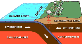
| Procedure | What
do students know about plate tectonics? Upon determining this, if
necessary, follow up with a general discussion of plate
tectonics introducing the types of
boundaries, convergent, divergent, and transform.Should
include a description of any activities or lessons you include to get
the students focused on the skills they will use to experience the
provocative phenomenon |
|
Type of Evidence |
Questioning. |
|
Teacher profile |
2.Ask
questions: What is a transform boundary.? Where would you
expect to find them? What is a convergent boundary? Where
would you expect to find one? What is a divergent boundary? Where
would you find an example of this? |
|
Student profile |
2.
Students will answer teachers' questions. |
| Provacative
Phenomenon |
Provide
students
with a Plate Tectonic Puzzle. Instruct students that they will
cut the
puzzle apart and assemble it as the plates appear today.
Students
will need a copy of the puzzle, scissors, glue sticks, red and blue
colored pencils.The
students will see how the present day plates fit together today and
using the directional arrows on the puzzle see that each plate has more
than one kind of boundary. |
|
Intent |
1.
Provide an experience to generate student observations: with
hands on experience with the puzzle, the product will show the students
understanding of the concepts of boundary types. |
|
Procedure |
Follow
the instructions listed in the Provacative Phenomenon. |
|
Type of Evidence |
Observation
of student's finished product. |
|
Teacher profile |
I'm
not sure what the reply should be here.!!!!!! |
|
Student profile |
4
Students will generate questions about the boundary types. |
| Debriefing |
1.Provides
an opportunity for students to ask questions about their finished
product. |
|
Intent |
That
students will come to the conclusions that they need to find out about
seismic activity. |
|
Procedure |
Lead
students in discussions that will lead them to the "I wonder"
statements of "What events occur along plate boundaries to determine
the type of boundary?" and "What kind of information do I need in order
to establish the types of boundaries? |
|
Type of Evidence |
Have
students write out questions they have about the activity they have
just completed. |
|
Teacher profile |
1
Provides the student the opportunity to generate the questions. |
|
Student profile |
4
Generate their own questions |
| Experimental
design |
Using
the puzzle that students have completed and providing them with a
blank world map with latitude and longitude have students
determine what information they will need to verify plate margine. |
| Data
collection |
Once
students have been led to understand that they need current
volcanic and earthquake activity. |
|
Intent |
1.
Allows learners to determine the datat that need to be collecteds. |
|
Procedure |
Provide
students with the needed web sites with instruction needed as to what
data needs to be collected. Volcanic activity for past two
years. Earthquake activity for earthquakes of a 5+ magnitude for
the previous month. <>http://earthref.org/cgi-bin/z-download.cgi?database_name=erda&search_start=advanced&h=html-header&file_path=/projects/earthref/archive/archive/aaab/m000017.i3.divergentmargin.jpg |
|
Type of Evidence |
Ask
questions. What information are you looking for? What are you
going to do with it? |
|
Teacher profile |
3.
Directs learners as to what evidence to collect and how to collect it. |
|
Student profile |
1.Given
data and told how to use. |
| Data
analysis |
Have
students compare puzzle and plotted data. |
|
Intent |
Students
see the relationship between volcanic and earthquake activity and
convergent boundaries., |
|
Procedure |
Should
include detailed instructions of the process and a description of any
content lessons necessary to achieve this stage |
|
Typre of Evidence |
Observation
of finished product. Questions: Where do you find most of
the earthquakes? Where do you find most of the
earthquakes? How do these relate to boundaries? Can
you formulate a theory for plate tectonics from this data? If so,
what is your conclusion? |
|
Teacher profile |
2
Guide learner to analyze and interpret data. |
|
Student profile |
4 Formulates explanation from evidence. |
| Presentation |
Teacher provides students an opportunity to prepare and communicate what they have learned. |
|
Intent |
That
students are able to present interpretation of the data they have
collected and manipulated. |
|
Procedure |
Should
include detailed instructions of the process and a description of any
content lessons necessary to achieve this stage |
|
Type of Evidence |
Test.
Questions: Along what kinds of boundary(ies) is most of the
seismic activity occurring? What can you deduce about the
activity and the other boundaries? What kind of information,
would you like to gather for those boundaries? |
|
Teacher profile |
3
Directs the learner with specific instructions on how to present the
information. This may be in the format of a written test. |
|
Student profile |
1.
Provided with a structured guideline for reporting information |
| CP0001 Expedition - Cruise Planning | Back to index |
| M00001 Simple Seafloor Spreading (Reykjanes Ridge) | Back to index |
| Standard | Subject | ||||||
| M00001 | Simple Seafloor Spreading | ||||||
| General Metadata | |||||||
| magnetic
anomalies, seafloor spreading, magnetic stripes, magnetism, magnetic
anomaly, mid-ocean ridge |
|||||||
| Level (L) | Images (I) | Data (D) | Text (T) | ||||
| 1-2 (Elementary) |
Photograph of bar magnet and nearby iron filings | Index Page | |||||
| 3 (Middle School) |
Magnetic Seafloor and Deeper Reversals | Table 1: Le Pichon 1968 | Index Page | Definition of Mid-Ocean Ridge | Index Page | ||
| 4 (High School) |
Age of the Seafloor Along Reykjanes Ridge | Index Page | Cross-Section Formation of Magnetic Anomalies with Geologic Timescale | Index Page | Definition of Seafloor Spreading | Index Page | |
| 5 (College) |
Magnetic Polarities Along Reykjanes Ridge | Index Page | Magnetic Poloraity and Ocean Depth Versus Longitude Along the Reykjanes Ridge | Index Page | Abstract-Heirtzler et al 1966 | Index Page | |
| 6-9 (Graduate & Research) |
Figure 1: Heirtzler et al 1966 | Index Page | Figure 2-Heirtzler et al 1966 | Index Page | Abstract-Heirtzler et al 1966 | Index Page | |
| M00002 Complex Seafloor Spreading | Back to index |
| Standard | Subject | ||||||
| M00002 | Complex Seafloor Spreading | ||||||
| General Metadata | |||||||
| magnetic
anomalies, seafloor spreading, magnetic stripes, |
|||||||
| Level (L) | Images (I) | Data (D) | Text (T) | ||||
| 1-2 (Elementary) |
Seafloor Spreading Animation | Index Page | |||||
| 3 (Middle School) |
Magnetic Particles in Oceanic Sediment | Index Page | Cross-Section Formation of Magnetic Anomalies with Geologic Timescale | Index Page | Text 01 from Vine 1966 | Text 01 from Vine 1966 | |
| 4 (High School) |
Magnetic Anomalies Off the Coast of the Pacific Northwest | Index Page | Geomagnetic-Polarity Epochs and Respective Age of Seafloor | Index Page | Text 04 from Vine 1966 | Text 04 from Vine 1966 | |
| Magnetic Anomalies and the Sea-floor Spreading Rate | Index Page | ||||||
| 5 (College) |
Figure 1-Vine 1966 (Raff & Mason) | Index Page | Table 1. Mid-Ocean Ridge Data Table (Wilson) | Index Page | Chapter 2 Mason - Oreskes | Chapter 2 Mason - Oreskes | |
| Multiple Maps of Diverging Plate Boundary and Cruise Paths | Index Page | Magnetic Profile and Map of Spreading Center | Index Page | ||||
| 6-9 (Graduate & Research) |
Magnetic Anomaly Data for Multiple Seafloor Locations | Index Page | Magnetic Anomlay Data from Multiple Seafloor Locations | Index Page | Chapter 3 Vine - Oreskes | Chapter 3 Vine - Oreskes | |
| Map of Diverging Plate Boundary and Cruise Path | Index Page | Magnetic Profiles and Map of Diverging Plate Boundary | Index Page | ||||
| M00006 Magnetic Reversals | Back to index |
| Standard | Subject | ||||||
| M00006 | Magnetic Reversals | ||||||
| General Metadata | |||||||
| magnetic field reversals, geomagnetic field reversals | |||||||
| Level (L) | Images (I) | Data (D) | Text (T) | ||||
| 1-2 (Elementary) |
Magnetic Reversal Video Along a Spreading Center | Index Page | Magnetic Rock Sample Polarity Data Table | Index Page | Definition of Magnetic Reversal - Elementary School | Index Page | |
| 3 (Middle School) |
Figure of a Normal and Reversed Magnetic Field | Index Page | Magnetic Reversal Data and Timescale | Index Page | Definition of Magnetic Reversal - Middle School | Index Page | |
| 4 (High School) |
Direction of Changing Magnetic Poles based on Basalt Samples in Japan | Index Page | Magnetic Reversal Data Table | Index Page | |||
| Magnetic Profiles | Index Page | ||||||
| 5 (College) |
Magnetic Field Reversal Video | Index Page | Magnetic Profile Data Across the East Pacific Rise | Index Page | |||
| 6-9 (Graduate & Research) |
Magnetic Reversals Based on Dipole and Nondipole Field Strength | Index Page | Paleomagnetic Data of Field Intensity and Polarity | Index Page | Chapter 6 - Oreskes: Morley | Chapter 6 - Oreskes: Morley | |
| M00008 Seamounts | Back to index |
| Standard | Subject | ||||||
| M00008 | Seamounts | ||||||
| General Metadata | |||||||
| Level (L) | Images (I) | Data (D) | Text (T) | ||||
| 1-2 (Elementary) |
|||||||
| 3 (Middle School) |
|||||||
| 4 (High School) |
Bathymetric map of the Magellan Seamount Trail including Vlinder Morphology Analysis | Index Page | |||||
| Bathymetry of the Magellan Seamount Trail | Index Page | ||||||
| Ralik and Ratak Seamount Trails | Index Page | ||||||
| 5 (College) |
Map of West Pacific Seamount Province | Index Page | |||||
| Map of the Japanese Seamount Trail | Index Page | ||||||
| WPSP Seamount Trails | Index Page | ||||||
| 6-9 (Graduate & Research) |
West Pacific Seamount Province and the Japanese Seamounts | Index Page | |||||
| Northern and Southern Wake Seamount Trails | Index Page | ||||||
| Euler Pole derivation | Index Page | ||||||
| M00013 Tectonic Plates | Back to index |
| Standard | Subject | ||||||
| M00013 | Tectonic Plates | ||||||
| General Metadata | |||||||
| plate tectonics, tectonic plates, crustal blocks, lithospheric plates | |||||||
| Level (L) | Images (I) | Data (D) | Text (T) | ||||
| 1-2 (Elementary) |
The Earth's Layers | Index Page | Plate Tectonics and Volcanoes | Index Page | Definition of Lithospheric Plates and Plate Tectonics | Index Page | |
| 3 (Middle School) |
The Major Tectonic Plates of the World | Index Page | Map of Tectonic Plates and Their Movement | Index Page | Fill-in-the-Blank Plate Tectonic Exercise | Index Page | |
| 4 (High School) |
Map of the North American Plate and the Eurasian Plate Diverging Over Iceland | Index Page | Geology of Africa and South America | Index Page | |||
| 5 (College) |
Diagram Illustrating Components of Plate Tectonics | Index Page | Movement between Tectonic Plates (Table 5) | Index Page | Chpt 1. -- Oreskes | Index Page | |
| 6-9 (Graduate & Research) |
Rates of Plate Rotation (Table 4) | Index Page | Abstract -- Morgan | Abstract -- Morgan | |||
| M00016 Convergent Boundaries | Back to index |
| Standard | Subject | ||||||
| M00016 | Convergent Plate Boundaries | ||||||
| General Metadata | |||||||
| Level (L) | Images (I) | Data (D) | Text (T) | ||||
| 1-2 (Elementary) |
The Eurasian Plate and Indian Plate Converging to Create the Himalayas | Index Page | |||||
| 3 (Middle School) |
Subduction Zone | Index Page | Relationship of Temperature and Earthquakes in a Downgoing Slab | Index Page | |||
| 4 (High School) |
The Collision of Two Continents | Index Page | Temperature Distribution in a Sinking Lithospheric Plate Compared to Surrounding Mantle | Index Page | Converging Plate Boundaries | Index | |
| Global image of the Pacific Margins | Index Page | ||||||
| 5 (College) |
|||||||
| 6-9 (Graduate & Research) |
|||||||
| M00017 Divergent Boundaries | Back to index |
| Standard | Subject | ||||||
| M00017 | Divergent Plate Boundaries | ||||||
| General Metadata | |||||||
| divergent plate boundary, spreading center | |||||||
| Level (L) | Images (I) | Data (D) | Text (T) | ||||
| 1-2 (Elementary) |
Simple Figure for a Divergent Boundary | Index Page | Simple Definition of Divergent Plate Boundaries | Index Page | |||
| 3 (Middle School) |
Image of a Divergent Boundary | Index Page | Heat Level Data Over Divergent Boundary | Index Page | Definition of Divergent Plate Margins - Middle School | Index Page | |
| 4 (High School) |
Divergent Boundary Between Two Continents | Index Page | Gravity Data Over Oceanic Ridge | Index Page | |||
| 5 (College) |
Topographic Map of a Divergent Plate Boundary | Index Page | |||||
| 6-9 (Graduate & Research) |
|||||||
| M00018 Strike Slip Boundaries | Back to index |
| Standard | Subject | ||||||
| M00018 | Strike-Slip Plate Boundaries | ||||||
| General Metadata | |||||||
transform faults, strike-slip faults |
|||||||
| Level (L) | Images (I) | Data (D) | Text (T) | ||||
| 1-2 (Elementary) |
3-D Image with Arrow Plate Motion | Index Page | |||||
| 3 (Middle School) |
Transform fault at Mid-Ocean Ridge vs. Seafloor Age | Index Page | Definition of Transform Fault | Index Page | |||
| 4 (High School) |
Fig. 1-Wilson 1965: Transform and Transcurrent Faults | Index Page | Text 01-Wilson
1965: Definition of Transform and Transcurrent Faults |
Text 01-Wilson
1965: Definition of Transform and Transcurrent Faults *need to scan & archive* |
|||
| 5 (College) |
Mendocino Transform Fault | Index Page | |||||
| 6-9 (Graduate & Research) |
Fig.3-Wilson 1965: Juan de Fuca Ridge and related faults | Index Page | Table 1-Wilson 1965: Location of points on Figure 3 | Index Page | |||
2004-07-19 09:15 AM