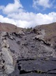
Lava flow into Kilauea
Caldera
| Local Time |
Date |
Lat / Lon in Deg/Min.DecMin |
Elevation |
Lat / Lon in Dec Degrees |
| 11:53:00L |
9/8/04 |
N19°24.324' |
W155°15.828' |
1098 m |
19.40558333 |
-155.26386667 |
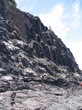
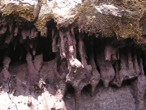
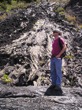
The first stop was at the Kilauea Caldera crater's southeast wall next
Keanakako'i Crater. There was a lav flow that emerated from a fissure
eruption above the Caldera. This eruption occurred in 1971, before the
formation of the 1974 Kilauea lava lake. Both types of flow mechanism are
present, junky A'A' and smooth Pahoehoe flow. The flow started out as
Pahoehoe and developed some A'A' on the way down beside the crater wall. The
main evidence for this is the presence of the some smooth Pahoehoe junks
(~10-20cm) in the A'A' flow.
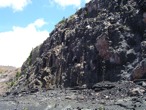
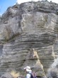
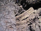
The 1974 lava flow created a bath tub ring around the magins of the Kilauea
Caldera.
This section, below the 1971 flow, of the bath tub ring is thicker than the
rest of the ring.
The size difference is caused be the 1974 flow flooded a shelf formed by the
1971 flow.
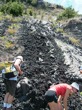
'A'a and pahoehoe flow
Dayna Cordano
|
'A'a and pahoehoe flow
Bettina Allmann
|
'A'a and pahoehoe flow
Bettina Allmann
|
|