Hawaiian Volcanoes Field Course 2004
UCSD ERTH 170/198 -- UCD GEL 138/198

Download Word Document for Day 5

Day 5:  September 10, 2004

Reporting:

Julie Bowles, Dayna Cordano, Ryan Miller (group 2)

East Rift Zone, including: 1974 Lava Flow (Lava Trees); Mauna Ulu Vent; Alae Shield; MakoÔopuhi Crater; Old Pulu Factory; Napau Crater with overlook of Pu'uou

Support Files:  A plot and the location of the overall hiking track is given in Figure 5-1 and Table 5-1, respectively

1974 Lava Flow and Lava Trees
 
Local Time Date Lat / Lon in Dec Degrees Elevation
9:45:00L 9/10/04 N19.4008 W155.25581 1129 m

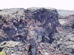
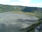
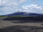
Our first stop was at a site of the 1974 lava flow just off the Chain of Craters Road, adjacent to the Lua Manu Crater. Two evident spatter ramparts show the source of the lava in this area. The distinctive features of this area are the so-called "lava trees" standing above the surrounding flow (left picture below). These were created when the flow erupted from the vents and engulfed the standing ohi'a trees. The lava quickly quenched against these moist hardwoods, leaving a chilled lava mold while the remaining hot lava continued to flow. 
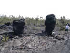
When lava then drained back into fissures, the surface of the flow lowered, and the quenched molds remained elevated above their surroundings, marking the maximum height of the flow (right picture below). The preserved molds are wider on the top, which is caused by methane gas released from the trees and rising upward, inflating the lava. This enlargement causes the molds to be top heavy, and many have toppled over. Paleo-flow direction can be deduced from a "seam" on the inside of the molds, indicating the down-flow direction. Seams in one mold here indicate paleo-flow in roughly a southerly direction. Following the event that created the created the lava trees, another spatter eruption must have occurred, as indicated by spatter found on top of the molds.


Lava tree molds
Marcel Croon

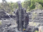
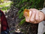
Lava tree mold with remanent of a charred tree visible
Marcel Croon
Mauna Ulu Area
 
Local Time Date Lat / Lon in Dec Degrees Elevation
11:25:00L 9/10/04 N19.37060 W155.204039 1049 m

Our second stop is the site of one of Hawai'i's biggest eruptions volumetrically in recorded history. Southeast of the main Kilauea caldera, the eruption started in 1969 and lasted for five years, ending in July 1974. Eruptions broke out along fissures, fed by a lava tube from the main caldera. The eruptions became focused in two vents - Mauna Ulu and 'Alae (Event 3) - and the high effusion rate led to the production of shields, rather than cones. On the flanks of the Mauna Ulu shield, we could see the remains of lava levee, marking the location of a perched lava lake (picture below). To the north of the shield, the 500-yr-old Pu'u huluhulu spatter cone remains preserved with no tephra coating from the 1969-1974 event; prevailing trade winds directed the fountain and tephra away from the cone. The eruptions here ended in 1974 with the beginning of the 1974 flow in the main caldera.


Remains of Mauna Ulu lava levee
Julie Bowles

'Alae Shield

Local Time Date Lat / Lon in Dec Degrees Elevation
11:58:00L 9/10/04 N19.36806 W115.19411 1027 m

The vent location for the Mauna Ulu eruption alternated between the Mauna Ulu shield (Event 2) and this one to the east, the 'Alae Shield. Exposures in the crater walls revealed thin layering of flows (picture below). This indicates a fluid flow with high eruption rate. The crater must have formed very near the end of the eruptions, because the broken lid on the crater floor remains uncovered by any later flows. As we approached the crater, the surrounding flows became visibly more red, indicating oxidation from hydrothermal activity. Steam from this activity can still be seen nearby. Dikes feeding the active flows at Pu'uou from beneath the main caldera pass through this area, their locations detected by seismic activity.


Lava flow into Alae crater
Julie Bowles
Mako'opuhi Crater
 
Local Time Date Lat / Lon in Dec Degrees Elevation
12:41:00L 9/10/04 N19.36292 W155.17476 914 m

This vent was last active in 1922 and 1964. In 1969, however, lava from the Mauna Ulu eruption flowed into the crater from the west. Vegetation in the eastern half of the crater marks the extent of the 1969 flow (picture below). The area around the crater also contains abundant reticulite. Reticulite can be considered the basaltic equivalent of pumice. However, rather than just being porous, it is highly permeable with interconnecting reticulum which mark the intersection of three bubbles.


Boundary of 1969 Maunu Ulu flow into Mako'opuhi Crater
Daphne Crane
Old Pulu Factory
 
Local Time Date Lat / Lon in Dec Degrees Elevation
13:58:00L 9/10/04 N19.37049 W155.15367 882 m

Event 5 was at the site of a former pulu factory (left picture below). Pulu (right picture below) is a soft material found in the crest of a tree fern which used to be used as stuffing for pillows and mattresses. The sign in front of the factory ruins reads:

Between 1851 and 1884 great quantities of pulu, the soft, reddish-brown fiber covering the coiled fronds of the tree fern (Hapuu), were harvested on Hawaii. Much of it was processed within these walls, later to be shipped from Keauhou landing to foreign markets for use as stuffing in pillows and mattresses.


Old Pulu Factory
Marcel Croon

Pulu fibers
Julie Bowles

Napau Crater with overlook of Pu'uou
 
Local Time Date Lat / Lon in Dec Degrees Elevation
14:10:00L 9/10/04 N19.37357 W155.14749 853 m

In 1984, volcanic activity at the Pu'uou crater began. By the late 1980s, the flow began to move eastward, but in 1991 a fissure opened up into Napu crater (picture below). Scientists believed the rift zone was going to rearrange itself, but shortly thereafter activity moved back to Pu'uou.


Napau crater with view of Pu'u'O'o
Julie Bowles
End of trip back at KMC
 
Local Time Date Lat / Lon in Deg/Min.DecMin Elevation
17:00:00L 9/10/04 N19°25.937' W155°16.414' 4111 ft