Hawaiian Volcanoes Field Course 2004
UCSD ERTH 170/198 -- UCD GEL 138/198

Download Word Document for Day 8

Day 8:  September 13, 2004

Reporting:

Mark Edwards, Lisa Haucke, Cara Johnson

Lava Tree State Park, Puna Geothermal Venture, Nanawale littoral cones, Tephra granulometry exercise at littoral cones.

Support Files: A pilot and the location of the overall hiking track are given in Figure 8-1 and Table 8-2, respectively.

Start at KMC
 
Local Time Date Lat / Lon in Dec Degrees Elevation
10:15:00L 9/13/04 N19.432 W155.274 4088 ft
Lava Tree State Park
 
Local Time Date Lat / Lon in Dec Degrees Elevation
11:00:00L 9/13/04 N19.805 W153.506 179 m

Our first stop was at Lava Tree State Park, where we had lunch. A small trail winds through the remnants of a lava flow from 1790 in which trees were enveloped in lava, creating casts of the trees (left picture below). The formation of the casts was helped by the draining of the lava from the area into fissures near the parking lot (right picture below). Some useful information can be gathered from this area, such as the height of the lava flow. This can be determined by measuring the height of the tree casts, which should be the same height as the top of the lava flow. They also serve as indicators of flow direction. The side of the tree cast that is down-flow has a seam where the flows going around either side of the tree met.


Lava trees in Lava Tree State Park
Vincent Morton

Fissure in Lava Tree State Park
Vincent Morton
Puna Geothermal Venture
 
Local Time Date Lat / Lon in Dec Degrees Elevation
11:55:00L 9/13/04 N19.805 W144.488 193 m

The next stop was at the Puna Geothermal Venture. It is located on the distal end of the southeast rift zone of Kilauea, near a sight of a rift-zone eruption in 1955. Multiple magma bodies undergoing differentiation below this site interact with water to create energy sources for hydrothermal vents. In 1975, a 2 km deep well was drilled in an attempt to harness the geothermal energy of this site (picture below). By 1981, the well was online and producing 3 Megawatts of energy, which is 25% of the electrical demand on the island of Hawaii. The process takes hot water and flashes it to steam. The brine and steam are separated, and the steam is used to run a turbine. The brine is re-injected into the system and steam not used to run a turbine initially is mixed with pentane and put through the process again. Though geothermal energy can be a very good alternative energy source, as can be seen in Iceland, the Puna Geothermal Venture is swamped with controversy. Environmentalists believed that the harnessing of geothermal energy would damage the environment with gas emissions and the native people saw it as a desecration of the land and Pele.


Energy well in Puna geothermal venture
Cara Johnson
Nanawale Littoral Cones
 
Local Time Date Lat / Lon in Dec Degrees Elevation
12:50:00L 9/11/04 N19.922 W153.454 48 m

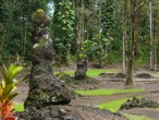
Our third stop brought us to the Nanawale Littoral Cones, the only two littoral cones that have developed on the coast of Kilauea during the last 200 years (Hazlett, field guide). The cones were formed during the 1840 eruption which originally started in the upper east rift zone of Kilauea (see image REGIONAL MAP.JPG). The first flow lasted less than a day. Several days later, the eruption renewed 15 miles to the east now in the lower east rift zone of Kilauea, near Pahoa and lasted 26 days. Caused by magma-seawater interactions a phreatomagmatic eruption is thought to have formed the tephra hills when hot A'a lava coming from the W entered the sea and was cooled rapidly.

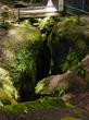
The quenching of the flows caused an explosive reaction in which the lava fragmented into tephra that settled as sandy hills on the coast, which formed into mixed layers of tephra and lava flows (top left picture below). Although a Pa'hoehoe flow makes up the basal unit of the stratigraphy, the A'a flows are thought to be the source of the tephra layers due to the fact that A'a lava has a larger portion of exposed surface area and therefore 
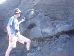
tends to end up in explosive events. Especially the northern cone was the location of the day's exercise. We studied the layers of the two sand hills (top middle picture below) to determine what might have caused them and to find out more about relationships between the several flows. By looking at the number and the orientation of the layers (top right picture below), we tried to reconstruct the different eruption cycles. Near the southern part of the cone no lava flows were found and the largest thickness of the Pa'hoehoe base was determined. The far north end in contrast contained the highest concentration of lava flows. The whole observation site is thought to be an alternating sequence of lava and tephra layers (bottom left picture below) The A'a flows are interpreted as flown sequencially into the wet sediment and build up pillow-like structures within these. Their structures sometimes appear with cavities in the center of the lava bodies (bottom right picture below) which were caused by rapid cooling of the outer lava skin and final degassing of the still liquid lava in the center.

Samples of different sites of the outcrop and originated in different layers were taken and will be dried, sieved, and weighed. Along with that data and the sizes of the ten largest grains in the samples, we will be able to learn more about the distribution of grain size within the cone that will help to reconstruct more details about the different events that took place.


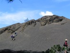
North Nanawale littoral cone
Marcel Croon

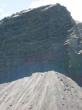
Layered tephra deposit
Dayna Cordano

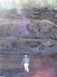
Layered stratigraphy of northern littoral Nanawale cone
Marcel Croon

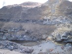
Detail of stratigraphic layers of Nanawale littoral cone
Cara Johnson

Pillow-like structure of lava formed in wet sediment
Vincent Morton
Da Store
 
Local Time Date Lat / Lon in Dec Degrees Elevation
15:24:00L 9/11/04 N19.58530 W155.44998 2504 m

Our last stop of the day consisted of providing ground-truth observations for an aerial photograph of a region near the top of Mauna Loa. In this region, we were just above the trade winds and the contrast in weathering with the first stop is readily apparent. In fact, the lack of weathering is useful because the color differences between the lava flows of different ages are clear. There are 4 different units located in the region with definite stratigraphic relations seen throughout.

An unusual feature found in this region is an accretionary lava ball. They are thought to form continuously during an aa flow, similar to a snowball. An alternative theory, not found in textbooks, is that they form from skylights in lave tubes, and then seen down slope from their origin. The skylight is an opening in the lave tube after roof collapse. This chunk of tube then becomes the nucleus of the accretionary lava ball.


Da store
Dayna Cordano
End of trip back at KMC
 
Local Time Date Lat / Lon in Dec Degrees Elevation
16:52:00L 9/9/04 N19.4338833 W155.27373 1367 m