ALIA Expedition
Ta’ū through the Hourglass: An alternative look ...
Anomalies have always caused restlessness in the minds of scientists throughout the world. They create frustration to the broadest degree imaginable in the sense that they are difficult to understand and more so to explain. This would at least hold true for scientists who allow passion to govern their behavior. The island of Ta’ū possesses its own unique set of physical and social anomalies. It has been a haven of scientific study for many various scientists. A clear example of this is the current Alia expedition, which partly seeks to understand its geologic evolution and that of its Samoan islands kin.
|
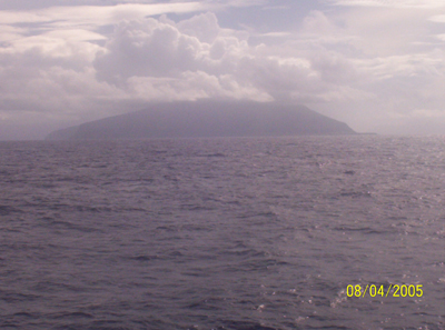
| Ta’ū island viewed from its eastern flank onboard the R/V Kilo Moana. Foto by Shaun Williams, Samoan Observer. |
This discussion will not emphasize these aspects. Rather, it raises the issue as to whether a historical account of the projected aerial morphology of the island is legitimate or not based on extreme variations with its existing dimensions. If you look closely at Ta’ū in Figure 1, notice its degree of morphologic variation from how it looks in Figure 2 and 4. Figure 1 is an account of the island in 1889, while Figure 2 and 4 illustrate its present form. Don’t worry too much about the variations in map scale between the two Figures. Rather, focus on how they differ morphologically irrespective of scale.
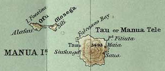 |
| Figure 1: Map of the Manu’a Islands in 1889. Source: Scottish Geographical Magazine, Vol. V, 1889. |
In 1889, the island looked more like a rounded volcanic cone, whilst at present it looks like a deformed horseshoe. Obviously apparent is the extreme variation in the south coast morphologies between the two depictions. Less apparent is the difference in the length of the north coast. There is no doubt that Ta’ū looks like it does in Figure 2. The question though is how it looked in Figure 1.
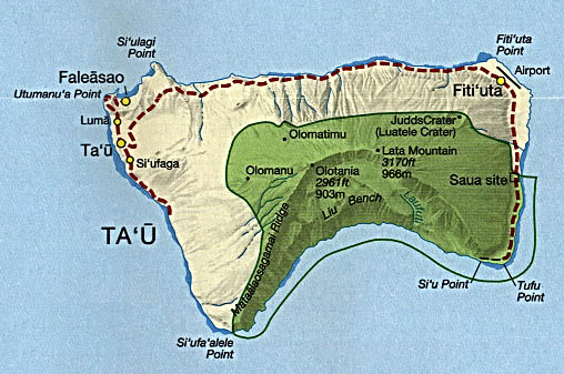 |
| Figure 2: Map of Ta’ū Island. Source: U.S National Park Service circa, 2002. |
Recent studies carried out by scientists leading the Alia expedition have confirmed that submarine fault scarps exist on the concave southern coast of the island. This means that active faulting in the area most probably caused it to look like it does today. At present, no one knows of the timing of these geologic events, or the rate at which they might have occurred (assuming a linear correlation exists). Subsequently, the depiction of Ta’ū in Figure 1 might lead one to believe that events which resulted in its current morphology took place at least in the last century.
With a summit of approximately 1,000 meters, and given that an approximate 100-year time gap exists between the two island depictions, one may argue that the southern coast has subsided along the fault scarps at a rate of about 8-10 meters per year. This assumes a linear correlation and does not account for external factors such as the influences of climatic and geologic extremes.
 |
| Figure 3: Shaded SRTM topography data overlaid with Landsat satellite image for the Ofu and Olosega Islands. Jasper Konter, Scripps Institution of Oceanography. |
Alternatively, if the causal events were catastrophic (rapid movement along the faults and mass wasting), then one would expect a significant amount of displacement to have occurred within the adjacent ocean. This might have favored the generation of a southward propagating tsunami. However, the likelihood is slim considering there exists no modern documentation of any known tsunami to have occurred during this time in New Zealand or Australia.
Unsurprisingly this argument causes the greatest of scientists to brush their beards and shake their heads in disagreement, and it is not difficult to understand why.
Any geoscientist who knows of and who has been to Ta’ū will acquire the immediate impression that its depiction in 1889 is the result of a simple cartographic error. Many would argue that geologic processes having the potential to create such extensive land modifications would not have occurred on a human time-scale (in this case, a century).
Most geoscientists would readily conclude that the ground-truthing techniques used by the pioneers who mapped it are at question, assuming they carried out ground-truthing at all. Furthermore, the fault scarps along the southern coast are not fresh as indicated by Matt Jackson (graduate student in the Alia expedition), suggesting that significant subsidence along them might have occurred earlier than 1889. Realistically this represents the geologically correct and accepted argument.
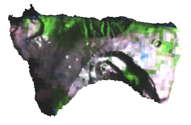 |
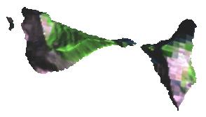
| Figure 4: Shaded SRTM topography data overlaid with Landsat satellite image for the Ta'u Island. Jasper Konter, Scripps Institution of Oceanography. |
But let us approach the issue more subjectively and explore the realm of possibilities. Firstly, the level of detailed definition of the island’s coastlines as well as the near accuracy of the island’s summit leads one to assume that the cartographers (in 1889) did carry out the necessary ground-truthing. Secondly, the relative accuracy of other Samoan islands (Tutuila, Upolu, and Savai’i) may also lead one to believe that Ta’ū was more or less accurate as well. Thirdly and perhaps foremost, it just seems unlikely that a distinguished society such as the Scottish Geographical Society, of which the cartographers belonged, could overlook such a pronounced error.
Other factors to consider are the impacts that land-influencing geohazards such as earthquakes and tropical cyclones may have had in modifying Ta’ū. The numerous cyclones and less prominent felt earthquakes that impacted the Samoas in the last century may have acted in accelerating erosion rates on the steep sided southern coast.
On the social front, if these major land-modifying processes occurred in the last century, one would immediately think that they should have been accounted for in oral history. Ironically the southern Ta’ū coastal area hosts no human settlement. Its steep walled cliffs do not favor any form of permanent human inhabitance. It is also unknown as to whether any social scientists explored the matter in Ta’ū’s oral history.
Overall, it seems that a scientific dilemma has manifested for those who choose to accept it. One thing is for certain though. Whether Ta’ū undertook a facelift in the past century, millennium, or eon, she undertook it regardless of which. Undoubted then is the fact that she will continue to remain a haven for scientific studies in the many years to come.
Shaun Williams onboard the R/V Kilo Moana.
| Alia Expedition Home Page |