Today we visited three places: the Hawaii Volcano Observatory, the newest lava flows on the island, and a littoral cone on the edge of the island. We learned about the latest advances in volcano monitoring and were able to learn from a legend in Volcanology: Don Swanson. We were hoping that we might be able to see some red hot lava just breaking out of its confinement, but we were not so lucky. However, we were able to see a plume of steam and gas coming from hot lava entering the ocean and forming a littoral cone. We were astonished how a town was wiped out in 1990, but the citizens have moved back and rebuilt. Now the 2010 lava flow has come back for a second meal. We ended the day trudging up and down a scree slope only for our project to fail (sorting the tephra by grain size).
Stop 1: Hawaii Volcano Observatory
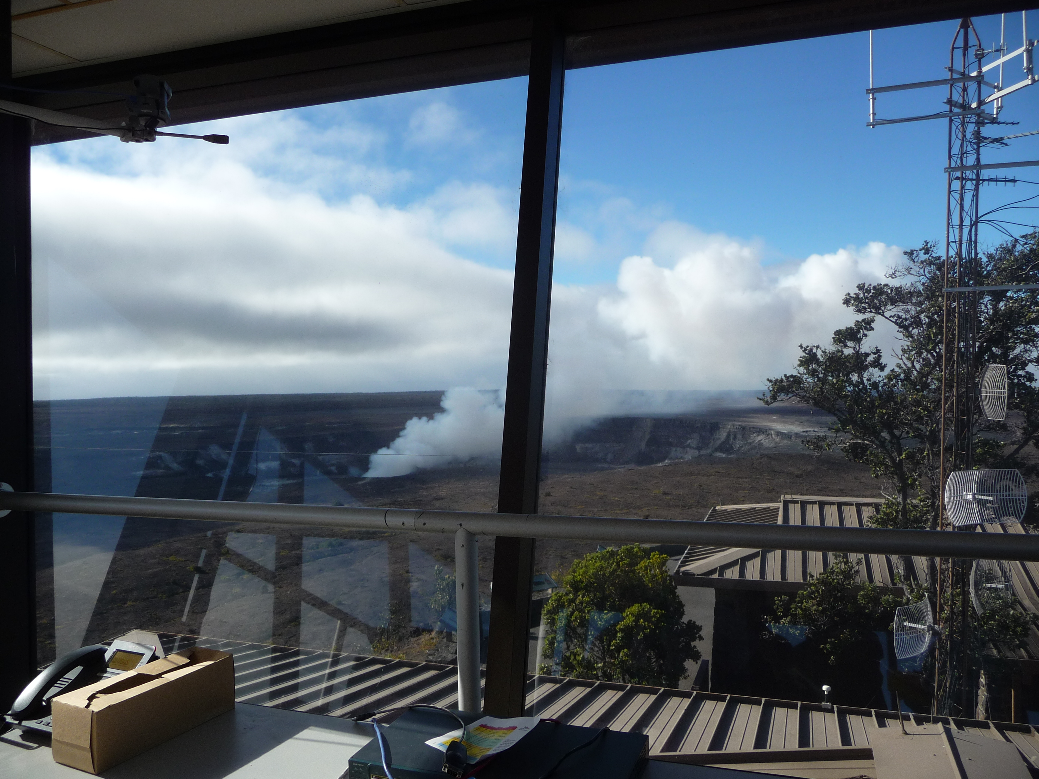
We sleepily started out the day a little early, at 7:30 am, and went to the Hawaii Volcano Observatory. There we met Mike Poland who explained the different ways that they monitor Kilauea. They monitor the volcano using gas, seismic, deformation, and geology data. There are different techniques within these categories, including INSAR and thermal images. In the thermal images, they can see where hot lava is at the surface, indicated by bright pixels on the screen. Mike had three screens devoted to seismic data. One screen had seismic data from Mauna Loa, one from the East Rift zone, and one from the Summit of Kilauea.
We learned that this morning, the seismograms went quiet! The cameras that were looking down into the vent showed that the lava lake had risen very high and the plume of gas coming from the lake disappeared. In the span of just a few hours, the lake drained and rose again. The cause of the rise could be from gas getting trapped inside, and then the drop occurs when the gas is released. The screen that showed the GPS data indicated that Kilauea began inflating in late 2009. Mauna Loa was inflating, but now it is holding steady.
The observatory has also installed extremely sensitive tiltmeters on the volcanoes. They can sense a tilt of one-tenth the height of a dime over a distance of 1 km. The tiltmeters line the rift zones and can track the flow of magma. The deflation at the summit and inflation in the rift zones shows magma draining. Mike told us that the summit of the volcanoes deflates and inflates every day or couple of days. He also has a radiometer that measures the temperature of the lava lake, and he saw that the temperature went up when the lava lake dropped. Soon, the observatory will install infrared cameras, which are being funded by the government stimulus. With the stimulus, the observatory was also able to hire a new employee to convert decades of seismograms to a digital format.
HVO is monitoring the amount of gas coming from the lava lake using UV spectrometers. They measure how much sulfur dioxide is coming from the lake by measuring the amount of UV radiation that makes it through the atmosphere. When the radiation decreases, there is more gas in the air. The lava lake at Halema’uma’u formed on March 19, 2008 from explosive eruptions. The lake is 150 m below the crater floor, but at times it can reach up to 100 m below the floor.
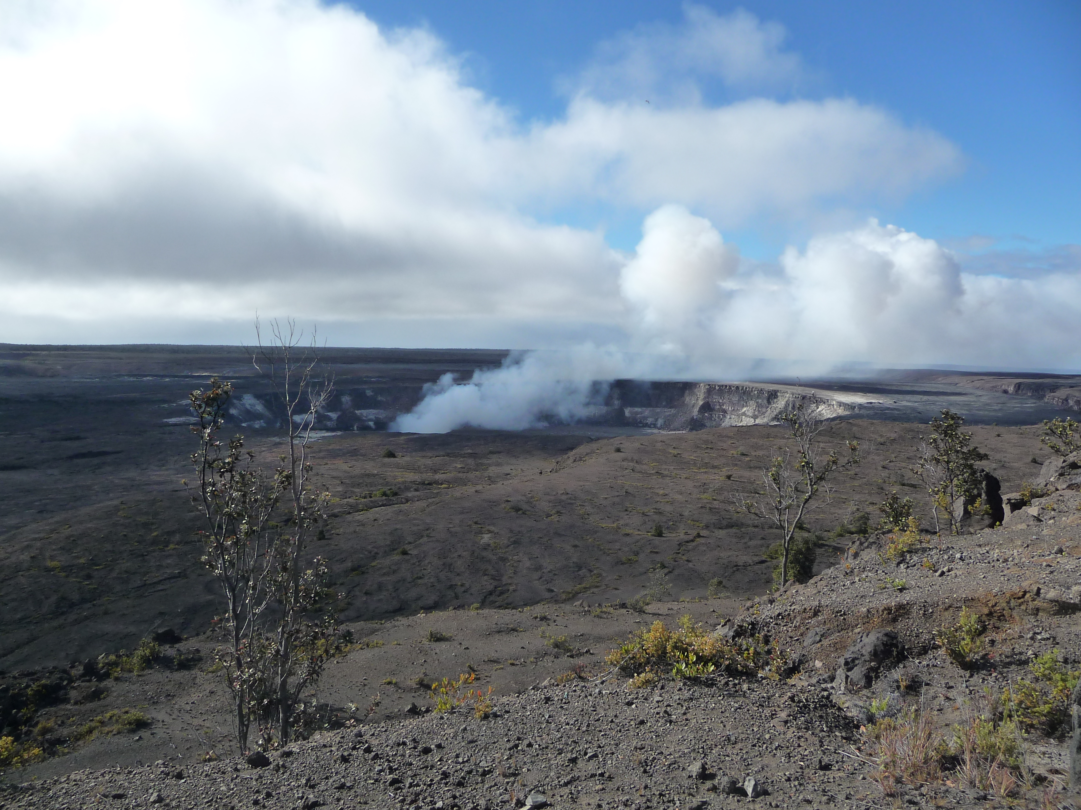
We climbed up to the overlook of Kilauea. There we learned that Mauna Loa last erupted in 1984. It normally erupts every 5 years, but it hasn’t erupted in 26 years, so a destructive eruption is imminent. There are a lot of people that live in very dangerous places on Mauna Loa. The lava can reach the ocean in only 24 hours, and it can erupt 1 year’s worth of Kilauea’s lava in only 3-4 weeks. We noticed that Pu’u O’o cannot be seen from this lookout. The data from Pu’u O’o must be sent to Mauna Ulu first and then to the observatory.
At one time, there was an observation deck where visitors could look directly onto the floor of the crater and see the lava lake. Then a vent formed and a huge rock was thrown up into the air. It destroyed the overlook and landed right on top of the fence, taking out an eighth of a mile of fence all at once. Halema’uma’u is 130 m wide now, but it began as a caldera only 35 m wide.
Don Swanson led the next part of our tour. We went outside to the edge of the crater. At one time the top of Kilauea was a smooth shield shape, but now this huge caldera cuts into the top of the volcano. It was once believed that the caldera formed in 1790, but recent evidence shows that it actually formed around 1500 AD. The events leading up to the enormous collapse began at the Thurston Lava tubes where lava flowed for 60 years, from about 1410 to 1470. Then the caldera formed and soon after tephra was spewed out and stuck onto the walls of the caldera. It burned down a forest and carbon-14 dating from the charcoal dates this event to around 1510. Therefore the caldera must have formed between 1470 and 1510. Hawaiian oral traditions describe this event. The caldera was much deeper then. Most eruptions in the caldera at this time were phreatomagmatic (formed by water mixing with hot magma). Therefore, the caldera must have been at or below the water table. The water table is around 515-520 m deep, so the caldera must have been around the same depth. The caldera filled in very rapidly from 1790 to 1920. There is a description of the caldera in 1823 by an English missionary named William Ellis. He became fluent in the Hawaiian language and was the first to make it into a written language. He describes the crater as around 450-500 m deep. Now it is only 120 m deep.
Although the age of the crater is now known, it is still a mystery as to how it formed. The classic hypothesis for the formation of a crater suggests that when a volcano erupts, all of the magma evacuates the chambers, and what is left falls in. However, 4-6 km3 is missing from this crater, and there is no lava flow of this immensity that is 500 years old. An alternate explanation for formation of the caldera suggests that a huge intrusion took place and the East rift zone opened up. However, if this is the case, there should still be excess heat radiating from the lava tubes, but there is not. A third outrageous hypothesis exists. It may have been formed from a collapse caused by the emptying of a reservoir. In this case, the lava would have erupted very slowly. One problem with this hypothesis is that a void this large should not be present for so long without being filled in, but it might not be so outrageous after all. Mines that humans have made have existed for 60 years, so surely nature could make a much better void. A second problem with this hypothesis is that if the reservoir was being emptied and no new magma was coming in, the volcano must have been cut off from the hot spot. Finally, if it was a slow eruption, pressure would be declining, so where would the pressure needed to erupt be coming from?
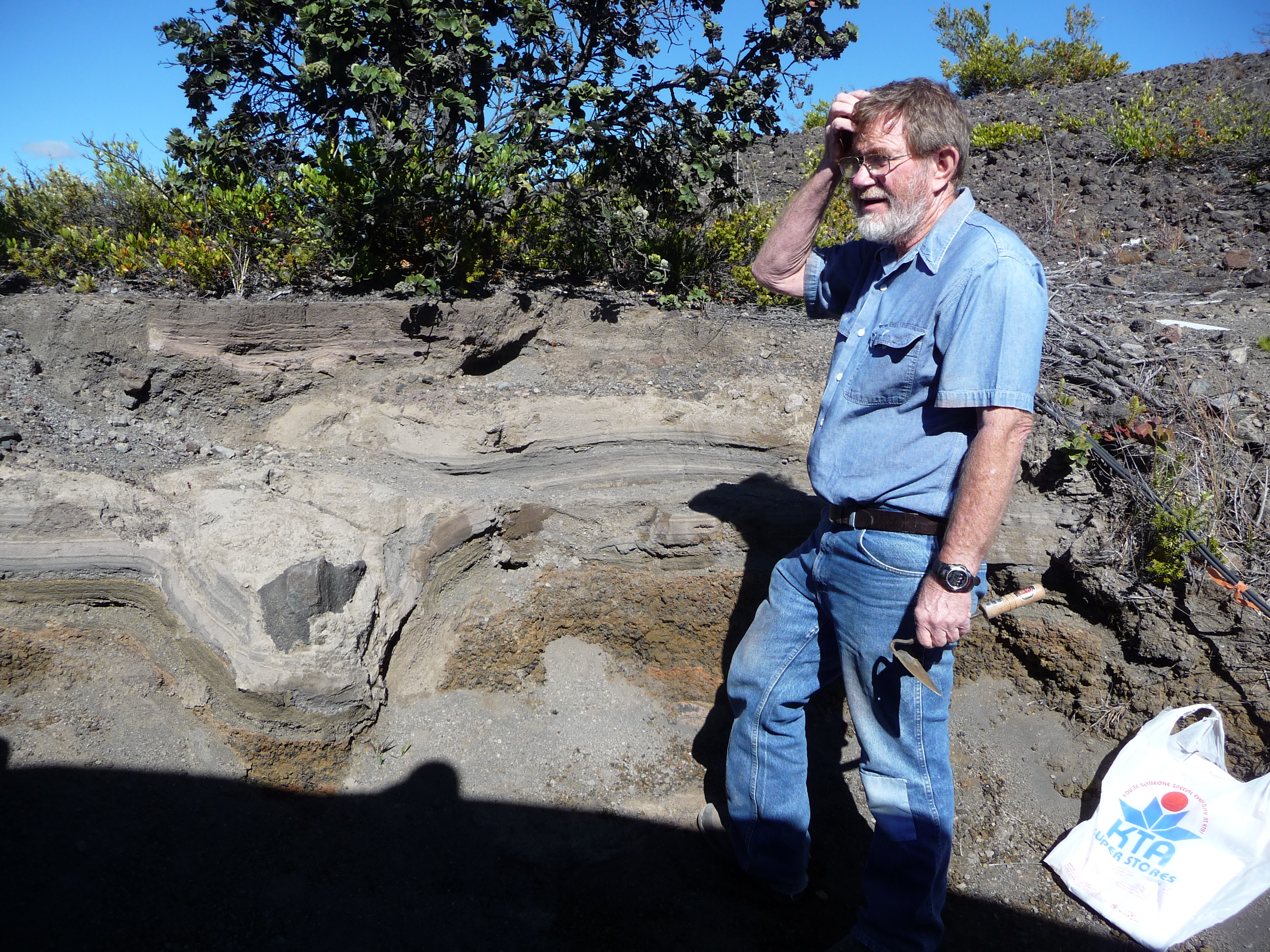
The last stop on our tour was at a stratagraphic section of layers of volcanic ash and tephra. We learned that Kilauea erupts explosively about as often as Mt. St. Helens, but it erupts more often overall. Out of all volcanoes in the U.S., Kilauea has killed the most people. Of several estimates of the number of warriors and their family members that were killed in 1790, the least is 80. Mt. St. Helens killed only 57 people.
The layers that we see in this section are on the side that the wind comes from, so a 4 cm thick layer here becomes 9 m thick down wind. There is a reticulite layer near the bottom that dates the formation of the caldera to around 500 years ago. This layer is almost purely reticulite. Magma has to rise very rapidly to form reticulite, and it is exclusive to basaltic eruptions. It is normally only a small percent of what comes out of a vent. It can be found all around the caldera, so there must have been several vents open at the same time. It might have been a ring fracture. Furthermore, reticulite has the texture of popcorn or honeycomb, so it is very light. Since it is so light, it can easily be blown away by the wind. Therefore, the eruption column had to be very high to deposit reticulite here, as well as wide enough to deposit it on this side of the caldera.
The next layer above the reticulite is made of glassy ash formed from interaction of magma with water. This was deposited between 1500 and 1650. The layer above this has a lot of lithic deposits. It was deposited between 1680 to the early 1700s. These are surge deposits that were produced by the collapse of low energy eruptions. They move close to the ground surface at hurricane speeds.
Further up is a layer of accretionary lapilli. Embedded in the top of this bed are footprints. Lithic ejecta was embedded in subsequent eruptions, so the lapilli must have still been wet when the lithics landed. The coarser surges are probably what killed people in 1790. It is still not known whose footprints are in the layer of lapilli, but there are some clues. First, in Hawaiian history there were warriors that attempted to cross Kilauea in 1790, but were killed by the eruption. Second, the length of a person’s foot is about 15% of their height. Based on the average length of the footprints, the average height of the people that made them was slightly over 5 feet tall. Europeans described Hawaiian warriors as especially tall. They averaged 5’ 10”. Therefore, women and young children must have made most of the footprints. More than half of the footprints were headed back in the direction of the eruption. The people may have been the families of the warriors that were headed back to find their loved ones, or maybe they were working there. They were found hanging on to each other, and they appeared to be sleeping. They were not covered in ash, so they must have been killed by a hot surge of air. They must have been hanging on to each other to keep from being blown away by the wind.
Above this is a mystery unit. This eruption was so high that it was seen from the North end of the island. The column must have gotten well up into the jet stream. It towered above Mauna Loa and Mauna Kea up to 9-10 km high.
I would have liked to listen to Don Swanson all day, but Professor Staudigel asserted that we needed to get going in order to finish everything we had to do today.
Stop 2: July 2010 Lava Flow

After an hour long drive, we arrived at the next stop on our journey. Here are the most recent lava flows on the island. The flows covered 2 miles of road in July of this year (2 months ago). Mike Poland showed us a fence that was lifted up by the lava flow when it inflated. We saw a large depression where the 2010 lava flow surrounded the 1990 lava flow. We were able to see the tube that is carrying lava to the ocean, marked by steam along its length. Sometimes cracks can open on the sides of the tube that allow lava out, but we were not lucky enough to see that. We walked over lava that broke out and cooled only 2 weeks ago. Further along on our walk, we saw the place where the lava is entering the ocean. We could not go close up to it because it was surrounded by a newly formed delta that could break away at any time. The ocean entry was throwing chunks of lava into the air where the lava hit the water and exploded because of a sudden loss of heat.
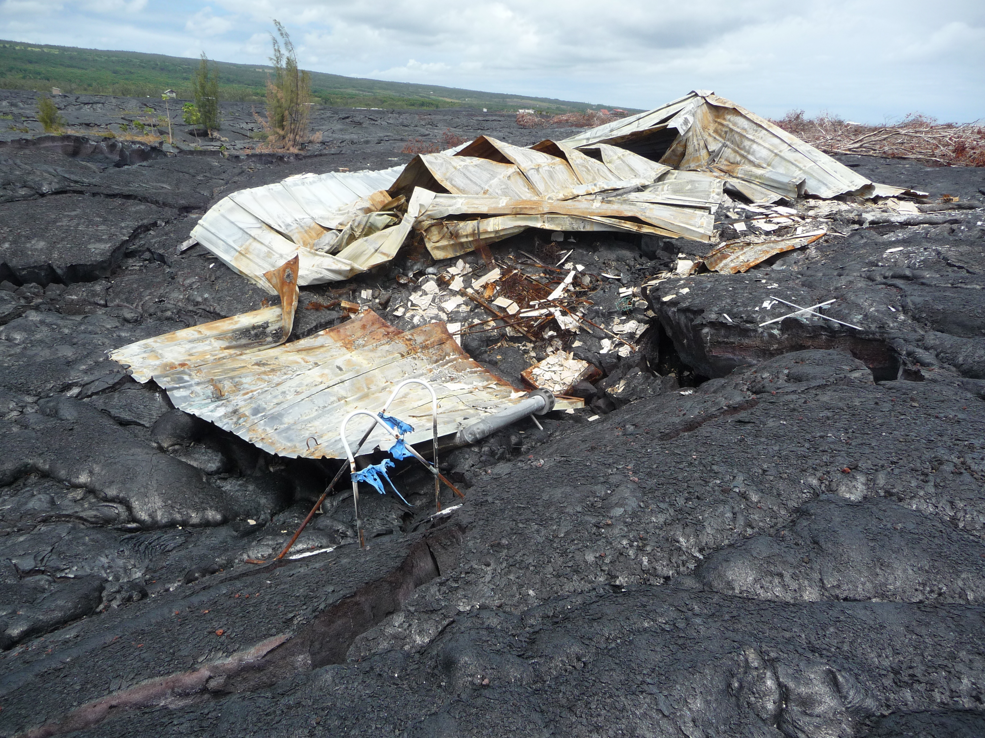
After lunch we walked over to Gary’s house. This is a house that was burned down just a couple of months ago by the lava flow. His water catch was lifted up and then dropped. The rocks that made up his driveway were carried along by the lava flow and scattered everywhere.
We learned of some experiments that Don Swanson did a couple of decades ago where he dumped tires and other random items in the lava lake trying to get it to turn over, or to see what else could happen.
Stop 3: Littoral Cone
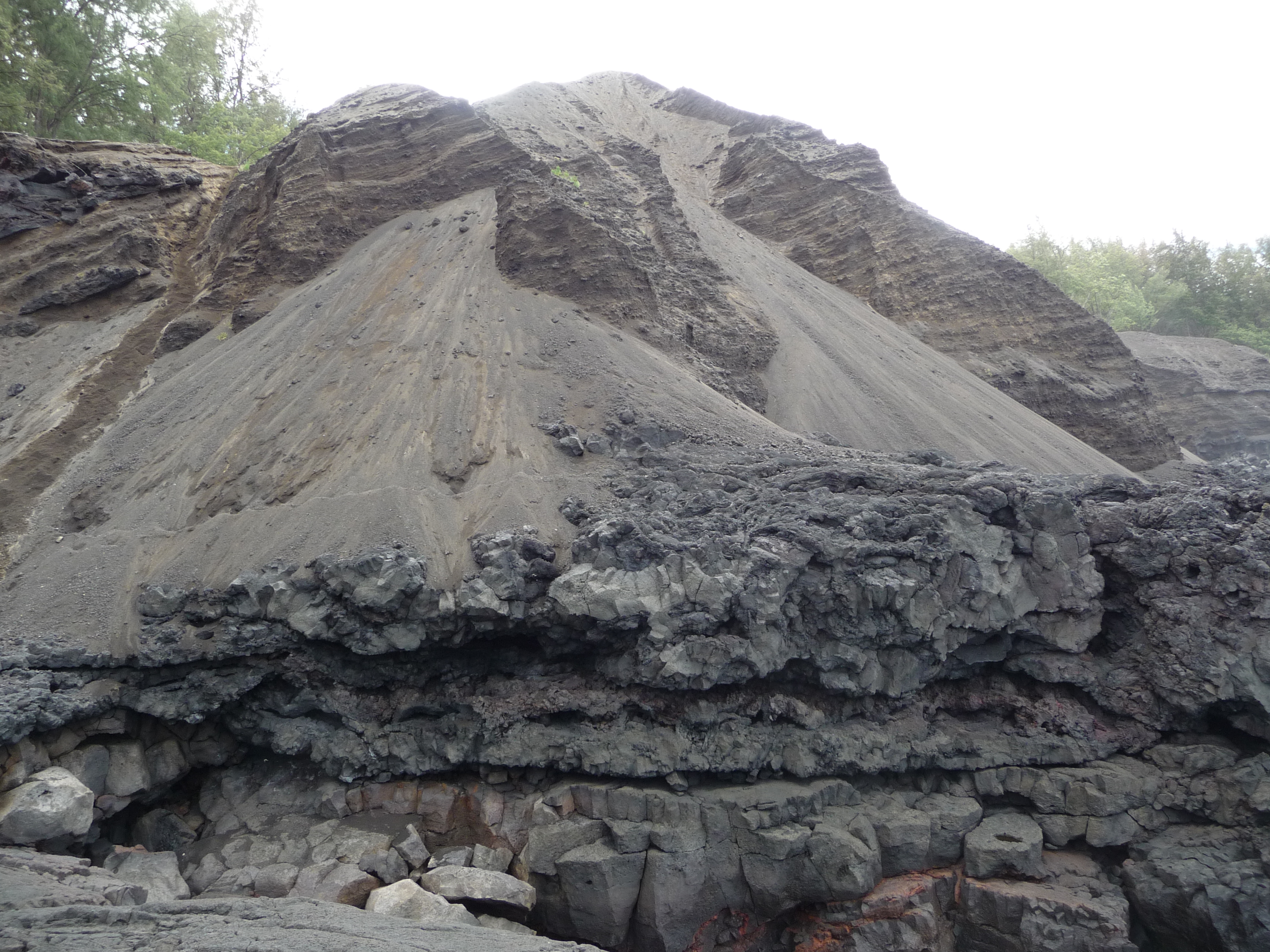
We got in the car and drove a long time again. We parked along a narrow dirt road and walked through a makeshift trash dump towards the ocean. Then we followed Professor Staudigel down a steep hillside made of sand. I tried my best to keep the sand out of my shoes, but they ended up full of sand anyways. At the bottom we discovered that this is a littoral cone on the very edge of the island. It was made by the interaction of water with hot lava. We saw that there was a line of littoral cones to one side of us, but not on the other. We sketched a diagram of the cones and then went back to the steep sandy slope of the cone for a closer look. There was a layer of lava on the bottom, and then many layers of tephra deposited on top. We measured the height of each layer and estimated the grain sizes, looking for any lithic fragments within the layers. We estimated that the curvature of the layers goes toward the center of the cone. The tephra is very fine and is made of basalt with some brown stuff in it. It was too small to tell if it was lithic or juvenile. We learned that when glass mixes with water it turns brown, so there might not be any lithics in the cone at all. The brown tephra makes up between 10 and 50% of the tephra.
Our final stop before we headed back to KMC was at a wonderful beach with a little lagoon. There were children playing in the lagoon and the water was a beautiful turquoise blue. We were given about 45 minutes to go swimming so we got out of the cars and tried to get into the porta-potties to change, but to our dismay they were locked. After debating how we were going to change, we ended up changing in the cars. We happily danced out to the water and jumped in. To our utter surprise, this was nothing like the beaches we were used to! Underneath the beautiful water was a dark foreboding underworld of ragged wrathful rocks. We decided to make the best of it, and swam out farther so we would not have to step on the rocks until Hung discovered that his swimming skills were not up to date. He tried to swim back to shore but the sea started devouring him until Jorge came to the rescue and pulled him to shore. In the process, both Hung and Jorge's feet got all cut up by the jagged rocks. Everyone else kept enjoying the water while Professor Staudigel bandaged up Hung and Jorge's feet. When we were told it was time to come in, only then did more of us discover that our feet were cut up as well. The picnic table was turned into a nurse's station and gauze and bandages went flying everywhere. This beach became the legendary beach known as "death beach" to some and "tickle beach" to others.
Prepared by: Natalie Juda and Paula Chojnacki
- 3632 reads