|
|
 |
 |
   |
|
|
|
|
|

|
|
We will keep you updated on the progress of the cruise via short news reports that will be posted as often as possible.
|
|
Day 28 - August 18, 2013
This day was spent dredging two spots on the South side of Tuscarora Bank. The Westernmost of the two (nicknamed Betchup)
brought up several types of basalts and volcanic breccias with Mn crust or as cores to Mn nodules. The more central dredge brought... Read more
|
|
Day 21 - August 11, 2013
We dredged a smaller seamount on the Southern border of the Melanesian Border Land (Silaga) and the Ellice Basin (that hosts
all the other Tuvalu Islands). This dredge yielded... Read more
|
|
Day 18 - August 8, 2013
The dredge on Telematua came back with basalt. After dredging we went near the summit and found a much
shallower depth than the 700 m on the charts. We proceeded...Read more
|
|
Day 14 - August 4, 2013
In the early morning hours we dredged the seamount (Na Kaa) to the North of Nui, picking a target
on previously collected bathymetry on our way to Mau Mau Seamount. This resulted in a large... Read more
|
|
Day 9 - July 30, 2013
Mapped the connection between the Gilbert Ridge into the Tuvalu Islands. Our initial destination
showed a seamount that appears in Smith & Sandwell bathymetry image version 14, but not... Read more
|
|
Day 1 - July 22, 2013
Left Apra Harbor (Guam) at 13.00 at the request of the Navy. Some of the ship�s equipment suffered from a lightning strike while in port. Of particular importance to the
success...Read more
|
|
| Read All News Updates |
|
|
|
|
|
|
|
|
 |
|
|
|
|
|
|
Here you can find short reports presenting some of the science behind the cruise, as well as blog stories about life on the R/V Roger Revelle. Reports will address topics mentioned in the Scientific Objectives as well as other basic geology topics, and are written for a general audience.
|
|
Science Report 3 - 24 August 2013 - LIBS System
On this cruise, the goal is to select the ideal sample set out of the rocks we pull in from dredges. In past expeditions, we relied on the expertise of PIs and students to
visually determine general characteristics of the rock samples from each dredge in order to...
Read more
|
|
Science Report 2 - 18 August 2013 - Getting Unstuck with the Dredge!
Dredging is what we do to haul up rocks from the ocean floor and seamounts. It is a basic and rudimentary technique (Figure 1) that has been around since the Challenger carried out...
Read more
|
|
Science Report 1 - 17 August 2013 - Mn-Crust
Here on research cruise RR1310 (R/V Roger Revelle, Year 2013, Expedition 10) our goal is to chip away at undersea volcanoes with the hopes of picking up good chunks
of pillow lavas or other lava flows into our dredge net. However, much of...
Read more
|
|
Blog 3 - 14 August 2013 - On the Bridge
The Bridge is to a ship as a cockpit is to an airplane. The Bridge of a ship is the command center through which all communication, work requests, and information is relayed.
It is the superstructure at the top of the ship that gives a clear view...
Read more
|
|
Blog 2 - 11 August 2013 - Survival at Sea
Of all the dangers of working at sea, shipwreck is probably the most vivid in people�s imaginations. When a ship goes down the crew is left stranded in what are often rough conditions
and cold water. At best they may have the basic emergency equipment found in a life boat and at worst they may be left floating with only a life vest on.
Part of going to sea as a scientist is learning how to stay safe in case of an emergency. Weekly safety meetings...
Read more
|
|
Blog 1 - 10 August 2013 - Creatures of the Deep
Three weeks ago, 20 scientists set out on an expedition to uncover the great mysteries of the earth. By dredging the ocean floor, we have obtained countless
rock samples that may hold valuable information. But what we didn't expect to find in our dredges...
Read more
|
|
|
|
|
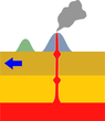
Science Report 5 - 25 March 2012 - Intra-plate Volcanism and Mantle Plumes
Of great interest to geologists is where seamounts occur on the ocean floor. Why does magma break the earth�s crust at these locations and not others? Active plate boundaries, such as mid-ocean ridges (e.g. Iceland) and subduction
zones (e.g. Japan) are clear sources of volcanism, but what processes...
Read more
|
|
| Read All Science Reports | Read All Blog Posts |
|
|
|
|
|
|
|
| |
|
 |
|
|
|
|
|
Rurutu 2013 Expedition
Browse through a gallery of pictures from the RR1310 cruise, showing life aboard the R/V Roger Revelle as we travel from Guam to Fiji.
|

Co-PIs on the Rurutu Hotspot project:
(From left to right) Anthony Koppers,
Jasper Konter
(Chief Scientist), Matt Jackson.
|

The members of the RR1310 science team.
|
|
| All Participants | View Image Gallery |
|
|
|
|
|
|
|
|
 |
|
|
|
|
|

|
Planned Cruise Path
This map shows the planned path of the ship as we wind our way through seamounts of the Rurutu hotspot. Additional targets may be added if there is extra time available.
|
|
|
See Larger Version |
|
|
|
|
|
|
|
|
 |
|
|
|
|
|
- Map out and trace the timing of the Rurutu bend using 40Ar/39Ar geochronology.
- Distinguish between the volcanoes of the Samoan and Rurutu hotspot tracks both chronologically and geochemically.
- Integrate the new age progression data into a new absolute plate motion (APM) model for the Pacific Plate.
|
|
|
Read More about the Scientific Objectives |
|
|
|
|
|
|
|
|
|
|
|
 |
|
|
|
|
|
 Your Oregon State University editors:
(From left to right) Susan Schnur, Kevin Konrad, Daniel Heaton, Anthony Koppers and Joanna Rose.
Your Oregon State University editors:
(From left to right) Susan Schnur, Kevin Konrad, Daniel Heaton, Anthony Koppers and Joanna Rose.
|
Exploring the Depths of the Southwest
Pacific
A team of 20 students and scientists led by Chief-Scientist
Jasper Konter will be at sea for
five weeks, mapping and dredging seamounts in the Tuvalu,
Samoa and Tonga overall region. The team consists of 12 undergraduate geology students, 5 graduate students in geology and oceanography, and 3 professors from University of Texas El Paso, Oregon State University and
the University of California in Santa Barbara. Over the next few
weeks we will keep you updated on our search of the Rurutu
hotspot in this region.
|
|
|
|
|
|
|
|